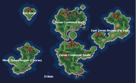
I'm a little disappointed. After studying this map quite a bit, I'm convinced that it was never intended to match the 1,000 AD world. Even if one bit here and there match up all right, the placement of the continents is off. Like, if the central landmass is Choras, and the next one is Medina, then Porre should not lay at the angle it does, nor should Guardia. That sort of thing.
Personally, I'm taking this image to be a throw-away that wasn't meant to show anything specific/canonical. It is only on the screen for half a second, after all. But at least they didn't use a bloody photograph of Earth this time!
The other alternative is one I suggested long ago- that Zenan is only one region of a much larger world, and thus might not be discernable on this map. I've since dumped that idea myself, though.
As for El Nido's location re: Zenan, Cross makes it plain that Porre is the "power of the east" and Zenan contains the "northern countries" relative to El Nido. There's wiggle room there, but it suggests to me that El Nido is in the far southern sea between Porre and Choras--a very remote region indeed.
To illustrate, here's an image I posted a long, long time ago:

Anyway, kudos to Jake-A-Roonie for capturing the image! Thank you!
OdF